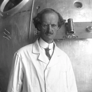

Bruce Heezen was an American marine geologist. Together with Marie Tharp, he mapped the floor of the Atlantic Ocean, revealing the Mid-Atlantic Ridge and its central rift valley — major contributions to the theory of plate tectonics.
Bruce Heezen
Bruce Charles Heezen
6 min read
Frequently asked questions
Key Facts
- Born on April 11, 1924, in Vinton (Iowa), died on June 21, 1977, off the coast of Iceland
- Worked at the Lamont-Doherty Geological Observatory of Columbia University
- With Marie Tharp, published the physiographic maps of the ocean floor starting in the 1950s
- Revealed the Mid-Atlantic Ridge and its central rift valley, decisive support for continental drift
- Co-author of the great world map of the ocean floor (1977), painted with Heinrich Berann
Works & Achievements
First detailed mapping of the central rift, a key clue to the mobility of the ocean floor.
Landmark monograph (with Tharp and Ewing) describing the structure of the North Atlantic and its rift system.
Popular-science article that introduced the general public to the great fissure of the ocean floor.
Pioneering photographic atlas showing what the deep ocean floor actually looks like.
Painted world map of the seafloor (with Tharp and the artist Heinrich Berann), the culmination of their work.
Revealing an underwater chain of more than 60,000 km encircling the globe, a major argument for plate tectonics.
Anecdotes
In the 1950s, Marie Tharp noticed a deep notch running down the middle of the Atlantic ridge on her maps. Bruce Heezen initially dismissed her idea as “girl talk,” because a central rift supported the controversial theory of continental drift. After checking, he had to admit she was right.
Since women were not allowed aboard oceanographic vessels at the time, Marie Tharp stayed on land while Heezen went to sea to collect the depth soundings. He brought back the data, and she turned it into maps: a two-decade collaboration in which neither could move forward without the other.
To locate underwater earthquakes, Heezen and Tharp overlaid the map of earthquake epicenters onto that of the ocean floor. To their surprise, the earthquakes lined up exactly along the central rift of the ridge. This coincidence became a major piece of evidence for plate tectonics.
For a long time, their seafloor maps could not be published as raw soundings, because the U.S. Navy regarded these data on ocean depths as military secrets in the midst of the Cold War. Heezen and Tharp got around the obstacle by producing painted “panoramas,” more artistic than technical.
Bruce Heezen died in 1977 aboard a research submarine, the NR-1, during a dive near Iceland, at the very heart of the ridge he had spent his life exploring.
Primary Sources
A continuous rift valley follows the crest of the Mid-Atlantic Ridge and coincides with the belt of seismic epicenters in the Atlantic.
A giant crack runs the entire length of the crest of the mid-ocean ridge, perhaps marking the place where the seafloor is spreading apart.
When I showed Bruce the rift I had traced, he dismissed it as “girl talk”; it took a year for him to accept it.
A physiographic depiction of the world's seafloor relief, revealing the continuous system of mid-ocean ridges.
Key Places
Small Midwestern town where Bruce Heezen was born in 1924, far from any ocean.
Columbia University laboratory where Heezen and Tharp worked for nearly thirty years to map the ocean floor.
Immense underwater mountain chain split by a central rift, the heart of Heezen and Tharp's discoveries.
University where Heezen pursued his doctoral studies and built most of his scientific career.
Region of the ridge, which emerges in Iceland, where Heezen died in 1977 aboard the submersible NR-1.