
A German Renaissance cartographer, he was the first to use the name “América” on a map, in 1507. His world map, printed in Saint-Dié-des-Vosges, depicts America for the first time as a distinct continent.
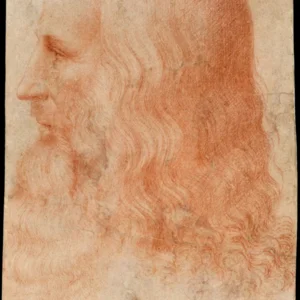
Martin Waldseemüller(1470 — 1520)
Martin Waldseemüller
margraviat de Hachberg-Sausenberg
8 min read
Frequently asked questions
Key Facts
- 1507: publishes the *Universalis Cosmographia*, the first map to name the American continent “América”
- 1507: writes the *Introductio Cosmographiae*, a treatise accompanying his world map
- Member of the Gymnasium Vosagense in Saint-Dié-des-Vosges, a humanist center in Lorraine
- His 1507 world map is inscribed in UNESCO’s Memory of the World Register
- Named America in honor of Amerigo Vespucci, whom he believed to be the discoverer of the new lands
Works & Achievements
Twelve-sheet planisphere, the first document to use the name América and to depict the New World as a distinct continent separate from Asia. Considered the cartographic birth certificate of America.
Explanatory text accompanying the large 1507 map, officially proposing the name América in tribute to Amerigo Vespucci and summarizing the state of geographical knowledge at the time.
A small world representation in segments designed to be cut out and glued onto a sphere. It is one of the earliest known globes to bear the name América, serving as a practical companion to the large wall map.
A revised and expanded edition of Ptolemy's Geography, enriched with modern maps including regional depictions of Europe. The New World is labelled Terra Incognita here, suggesting Waldseemüller wished to reconsider his 1507 choice.
A large twelve-sheet nautical map focusing on Portuguese and Spanish navigation routes. It represents a major update to the geographical knowledge accumulated since 1507 through exploration.
Anecdotes
In 1507, Waldseemüller published in Saint-Dié-des-Vosges a world map on which he inscribed for the first time the word “América” to designate the new continent. He chose this name as a tribute to the Florentine explorer Amerigo Vespucci, convinced that it was he who had first understood that this was a land entirely unknown to the Ancients.
Waldseemüller seems to have regretted naming the continent “América”: on his later maps, notably his 1513 edition of Ptolemy, he erased the name and replaced it with “Terra Incognita.” But it was too late — the name had already spread throughout Europe, and no map could dislodge it.
The 1507 map, printed on twelve sheets that could be assembled into a world map roughly 2.4 m × 1.3 m, was produced in about a thousand copies. Yet only one complete copy has survived to this day: it was discovered in 1901 at Wolfegg Castle in Germany, and the Library of Congress purchased it in 2003 for ten million dollars.
Waldseemüller worked within a circle of humanists gathered in Saint-Dié-des-Vosges under the patronage of Duke René II of Lorraine. His friend Matthias Ringmann likely wrote much of the text of the Cosmographiae Introductio that accompanied the map and formally proposed the name “América” — a fine example of collective humanist scholarship in the Renaissance.
Primary Sources
"And inasmuch as both Europe and Asia received their names from women, I see no reason why anyone should justly object to calling this land Amerige, that is, the Land of Americus, or America, after Americus, its discoverer, a man of great ability." (Since Europe and Asia received their names from women, I see no reason to refuse calling this land America, after its discoverer Amerigo, a man of great intellect.)
A twelve-sheet map representing for the first time the Americas as a distinct continent, separated from Asia by an ocean. The inscription AMERICA appears on the southern portion of the new continent.
Waldseemüller's second major map, focused more on maritime routes than on theoretical geographical representation. It partly replaces the name America with Portuguese designations and corrects several coastal outlines.
An edition of Ptolemy's Geography expanded with modern maps by Waldseemüller. The map of the New World bears the inscription Terra Incognita instead of America, reflecting the author's uncertainty about who truly deserved credit for the discovery.
Key Places
City where Waldseemüller worked at the Gymnasium Vosagense, a humanist circle patronized by Duke René II of Lorraine. It was here that the 1507 map and the *Cosmographiae Introductio* were printed — the works that gave America its name.
Town in Baden-Württemberg often cited as the probable birthplace of Waldseemüller around 1470, though sources on his early life remain scarce and sometimes contradictory.
Waldseemüller likely attended the University of Freiburg im Breisgau, one of the great Rhenish humanist universities of the late 15th century, where he is thought to have acquired his training in geography and Latin.
Castle in Upper Swabia where, in 1901, Jesuit priest Joseph Fischer discovered the only known complete copy of the 1507 map, which had been preserved since the 16th century in the archives of the Waldburg-Wolfegg family.
Current home of the only complete surviving copy of the 1507 *Universalis Cosmographia*, acquired in 2003 for ten million dollars. The map is displayed there as a treasured landmark of American history.