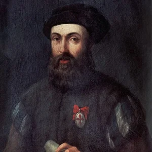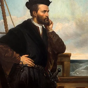

French explorer and navigator (1492–1557) who undertook three major voyages to North America between 1534 and 1542. He explored the St. Lawrence River and the coasts of Canada, paving the way for French colonization of New France.
Jacques Cartier(1492 — 1557)
Jacques Cartier
royaume de France
8 min read
Frequently asked questions
Key Facts
- 1534: First voyage to North America; discovery of the Gaspé Peninsula and Anticosti Island
- 1535–1536: Second voyage; exploration of the St. Lawrence River as far as Hochelaga (present-day Montreal)
- 1541–1542: Third voyage; unsuccessful attempt to establish a permanent colony in New France
- Mapping of the Canadian coastline and collection of major geographical information
- Encounters with Indigenous peoples (Iroquoians) and establishment of trade relations
Works & Achievements
On this first voyage, Cartier explored the coasts of Newfoundland, Prince Edward Island, and the Baie des Chaleurs, mapping the Gulf of St. Lawrence for the first time and paving the way for future voyages.
On his second voyage, Cartier sailed more than 1,600 km up the St. Lawrence River, discovering Stadacona and Hochelaga. This was the deepest inland penetration of North America achieved by a European up to that point.
The official account of Cartier's second voyage, published in Paris, it is the only authenticated text published during his lifetime. It stands as an essential primary source on the Indigenous peoples and Canadian landscapes of the 16th century.
Cartier founded the first European colonial settlement in Canada, laying the groundwork for the future New France, even though the colony was abandoned in 1542 due to insufficient support from the home country.
Across his three voyages, Cartier produced the first systematic cartography of the Gulf and St. Lawrence River, providing later European explorers and navigators with indispensable maps for penetrating North America.
Anecdotes
During his first voyage in 1534, Jacques Cartier planted a ten-meter cross at Gaspé, in the name of King Francis I. The Iroquois present, led by chief Donnacona, strongly protested this act of territorial possession. Cartier managed to convince them that the cross was simply a navigation marker, then had two of Donnacona's sons brought aboard to take them to France.
During the winter of 1535–1536, trapped in the ice near Stadaconé (present-day Quebec City), Cartier's crew was decimated by scurvy. More than 25 sailors died before an Iroquois man revealed to Cartier a miraculous remedy: a decoction of bark and leaves from the annedda tree (white spruce or white cedar). Within days, the sick men recovered, and Cartier noted that this plant had saved his entire expedition.
Convinced he had discovered a rich deposit of gold and diamonds at Cap-Diamant, Cartier returned triumphantly to France in 1542 with barrels full of these precious minerals. Analysis revealed that the gold was nothing but iron pyrite and the diamonds mere quartz crystals. This misadventure gave rise to the French expression "as fake as Canadian diamonds".
During his second voyage, Cartier became the first European to sail up the St. Lawrence River as far as Hochelaga, the great Iroquois village where Montreal stands today. He climbed the nearby mountain and named it Mont-Royal, thus giving rise to the name of the future city. From the summit, he spotted the Lachine Rapids, which blocked all navigation westward, putting an end to hopes of a passage to Asia.
Primary Sources
On the following 10th of August, the feast day of Saint Lawrence, we entered into the said gulf, to which we gave the name of the Bay of Saint Lawrence, because the said day is the feast of the said saint.
We had a cross made thirty feet high, and had carved upon it, in relief, a wooden tablet on which was written: Long live the King of France. And we planted this cross on the point before them, making signs to them, looking up and showing them the sky, that by it was our redemption.
The said Cartier and his men found certain mines of what they believed to be gold and silver, along with stones they took for diamonds, and loaded their ships with them to bring back to France.
We have appointed and ordained you, and do appoint and ordain you by these presents, to make the voyage to Terre Neuve, with ships armed and equipped, to discover certain islands and lands where it is said there must be found great quantities of gold and other rich things.
Key Places
Cartier's birthplace and home port for his three expeditions. A major Breton maritime city, it was one of France's principal trading and fishing ports in the 16th century.
The site where Cartier planted a cross on July 24, 1534, in the name of Francis I — a founding act of French presence in North America. This symbolic gesture is considered the starting point of New France.
A large Iroquois village on the banks of the St. Lawrence River, site of Cartier's encounter with chief Donnacona. Cartier wintered there twice and made his first attempts at building a fort, foreshadowing the future city of Quebec founded by Champlain in 1608.
A large Iroquois village of approximately 1,500 inhabitants that Cartier visited in October 1535. He climbed the nearby mountain, which he named Mont-Royal, giving rise to the name Montreal.
The first French colonial settlement, founded by Cartier in 1541 during his third voyage. Abandoned the following year due to cold, disease, and tensions with the Iroquois, it remains the first attempt at permanent French colonization in America.
Liens externes & ressources
Références
Œuvres
Premier voyage et exploration de la baie des Chaleurs (1534)
1534
Remontée du Saint-Laurent jusqu'à Hochelaga (1535-1536)
1535
Brief récit et succincte narration (Relation du deuxième voyage)
1545
Fondation de Charlesbourg-Royal (1541)
1541
Cartographie du fleuve Saint-Laurent
1534-1542