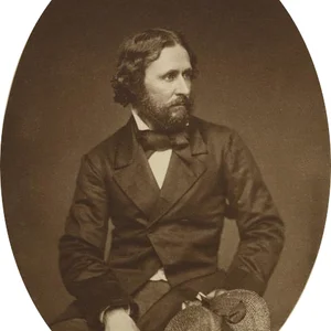

An American army officer and explorer, William Clark co-led the Corps of Discovery expedition (1804–1806) with Meriwether Lewis, commissioned by President Jefferson. The expedition crossed North America to the Pacific Ocean, paving the way for the settlement of the American West.
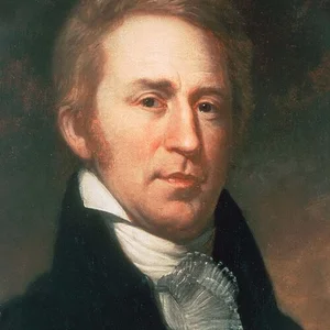
William Clark(1770 — 1838)
William Clark
États-Unis
9 min read
Frequently asked questions
Key Facts
- 1770: Born in Virginia
- 1804–1806: Co-leads the Lewis and Clark Expedition from Saint Louis to the Pacific
- 1807: Appointed Superintendent of Indian Affairs for the western territories
- 1813–1820: Governor of the Missouri Territory
- 1838: Dies in Saint Louis, Missouri
Works & Achievements
Written daily throughout the two years of the expedition, these journals stand as an exceptional ethnographic, geographic, and naturalist document. They describe more than 170 plant species and 120 animal species previously unknown to European scientists.
A manuscript map, later engraved, that for the first time accurately depicted the entire territory between the Mississippi and the Pacific. It served as the reference map of the American West for over twenty years and guided thousands of settlers.
As Superintendent of Indian Affairs, Clark negotiated and signed dozens of treaties with the nations of the Mississippi Valley and the Plains. His approach, considered more respectful than that of his contemporaries, earned him the nickname “Red Head Chief” among several peoples.
Clark assembled in Saint Louis a unique collection of objects, paintings, and Native American artifacts received during diplomatic negotiations. This museum, open to the public, was one of the first ethnographic museums in the United States.
An official document submitted to President Jefferson at the conclusion of the expedition, presenting the routes discovered, the peoples encountered, the natural resources found, and recommendations for establishing trading posts in the West.
Anecdotes
Although Thomas Jefferson had wanted to make Clark a full captain, the U.S. Army granted him only the rank of lieutenant. Lewis refused to accept this injustice and continued to call his companion 'Captain Clark' throughout the expedition, sharing with him a strictly equal command. Not a single man of the expedition ever questioned this decision.
Clark brought with him York, his enslaved servant, for the entire expedition. York was the first Black man that many Native American nations had ever seen; some warriors tried to rub his skin to see if the color would come off. His physical strength and skill at hunting earned him immense respect among Native Americans, who regarded him as a being possessed of exceptional powers.
Clark was a self-taught cartographer of genius. Using only a compass and a sextant, he drew maps of the American West with remarkable accuracy for the time. These maps, reproduced and widely distributed after the expedition's return in 1806, became the definitive reference for decades of westward migration.
Upon his return, Clark took the young Jean-Baptiste Charbonneau under his wing — the son of Sacagawea and Toussaint Charbonneau, born during the expedition itself. He affectionately nicknamed him 'Pomp' and funded his education in Saint Louis, turning this child born in the Rockies into an educated man who spoke four languages.
When the expedition returned in September 1806, the people of Saint Louis welcomed Lewis and Clark as heroes, having long believed them dead. The two men had traveled more than 12,000 kilometers over two years and four months, lost only one man (to illness, not violence), and had never fired a single shot at a Native American.
Primary Sources
Set out at half past three oClock under a jentle breese from the S. E. Proceeded on verry well. The Country on both Sides is fine, the land rises gradually from the river.
We are now at the Pacific Ocean which we have been So long anxious to See, and the roeing of the waves may be heard distinctly.
In obedience to your orders we have penetrated the Continent of North America to the Pacific Ocean, and sufficiently explored the interior of the country to affirm with confidence that we have discovered the most practicable rout which does exist across the continent.
Handwritten map representing the entire Missouri basin, the Rockies, and the Columbia River down to the Pacific Ocean, drawn from observations and surveys conducted between 1804 and 1806.
My duty is to protect the interests of the United States while treating with justice and humanity the Indian nations whose lands and ways of life are forever changed by our Republic's expansion.
Key Places
William Clark was born on August 1, 1770, into a family of Virginia planters. His family left Virginia for Kentucky in 1785, where he grew up on the wild frontier.
A winter camp where Lewis and Clark assembled and trained their party from May 1803 to May 1804. It was from this camp, situated across from the mouth of the Missouri River, that the expedition set out on May 14, 1804.
A fort built by the Corps of Discovery to winter over in 1804–1805, near the Mandan and Hidatsa villages. It was here that Sacagawea and her husband Charbonneau joined the expedition as interpreters.
A fort built at the mouth of the Columbia River for the winter of 1805–1806. Its location marked the culmination of the transcontinental crossing; Clark finalized his cartographic surveys there and prepared the return report.
The city where Clark settled permanently after the expedition, serving as Superintendent of Indian Affairs and later as Territorial Governor. He died there on September 1, 1838, and is buried there.