Imaginary interview with Marie Tharp
by Charactorium · Marie Tharp (1920 — 2006) · Sciences · 5 min read

Palisades, New York, late 1970s. In an office at the Lamont Geological Observatory overlooking the Hudson Valley, a small woman leans over a huge drafting table covered with ink-drawn profiles. The freshly published World Ocean Floor Panorama is pinned to the wall. Marie Tharp agrees to look back on forty years spent drawing a world she never touched.
—How did one work in the 1950s to map an ocean one had never seen with one's own eyes?
I was forbidden, plain and simple. The research ships of Columbia didn't want a woman on board — an old sailor's superstition, a woman's presence brought bad luck. So I stayed on shore, at Palisades, and waited for the mail. Columns of numbers arrived in bundles, collected at sea by my colleagues, and it was my job to turn them into relief. I'd unroll the sounding sheets on my big table, take my black coffee, and draw. Profile after profile, I reconstructed mountains, valleys, escarpments no one had ever seen. I drew the floor of the Atlantic without ever having dipped a sounding line into it myself.
I drew the floor of the Atlantic without ever having dipped a sounding line into it myself.
—How did it feel to reconstruct landscapes you knew you could never explore yourself?
A strange intimacy, I think. My colleagues saw the water, the deck, the foam; I saw the rock, the rift, the exact slope of the continental rise. They brought back sediment cores and photographs of the bottom, and I used them to check my drawings, like comparing a portrait to its model. The truth didn't come from the rough sea but from those quiet numbers aligned on tracing paper. That's where everything happened, in India ink, in the silence of the lab. The ocean floors do not lie — they just needed someone patient enough to listen, line after line.
They saw the water; I saw the rock, the rift, the exact slope of the continental rise.
—Can you tell us about the moment you realized there was a valley at the center of the mid-ocean ridge?
It was 1952. I was plotting the bathymetric profiles of the North Atlantic, methodically, and a pattern kept recurring: a deep V-shaped notch, repeated at the center of the submarine chain, from one transect to the next. A rift valley, like those created by the pulling apart of land. My heart pounding, I understood that I might have the geographical proof that Wegener's old idea, continental drift, had been missing — the idea everyone had ridiculed for forty years. It wasn't a vague intuition: it was written, again and again, in kilometers of sonar data that lay under my fingers.
A deep V-shaped notch, repeated — I knew I held the missing proof.
—How did Bruce Heezen react to this discovery?
Badly, at first. When I showed him my valley, he waved it away: girl talk, women's stories. Continental drift, in his eyes, was a heresy beneath a serious geologist. It took me two years. Two years, until we overlaid the map of submarine earthquake epicenters onto my profiles — and the earthquakes lined up obediently in the hollow of my rift, exactly where I had drawn it. Faced with that coincidence, Heezen could no longer deny it. It was no longer my opinion against his: it was the Earth itself signing my maps.
It was no longer my opinion against his: it was the Earth itself signing my maps.
—You had to invent the very way of representing these seafloors. How does one proceed when no convention exists?
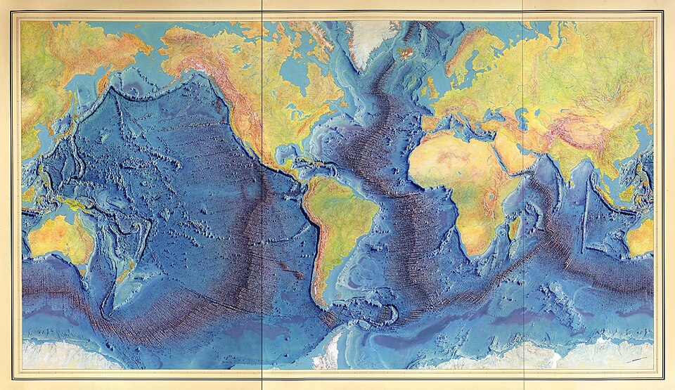
One borrows, then invents. For land relief, cartographers had centuries of conventions; for the seafloor, there was nothing. So I turned to topographic maps of the continent, studied their shading, their ways of suggesting a slope, a summit, and adapted that grammar to a submerged world. Everything was done by hand, in India ink on tracing paper, in superimposed layers that were endlessly corrected. The 1957 map of the Mid-Atlantic Ridge was the first alphabet of this language — a semiology born of a drafting table, a ruler, and a goldsmith's patience.
For the seafloor there was nothing: I had to invent the grammar of a submerged world.
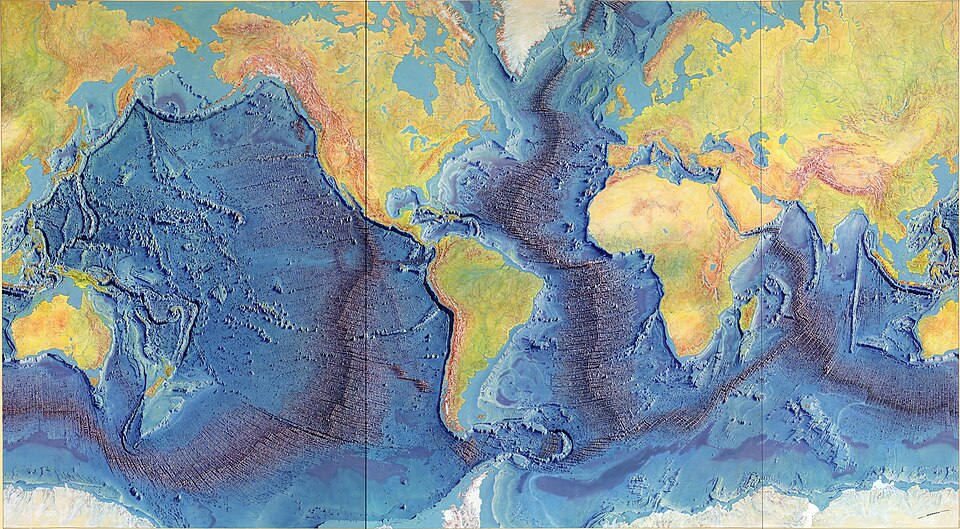
—The great panorama of 1977 struck people by its beauty as much as its science. How was it born?
From the meeting of numbers and a brush. The data, the architecture of the relief, the location of each ridge — all that came from me and Heezen, twenty-five years of accumulated profiles. But for the World Ocean Floor Panorama, we entrusted the imagery to the Austrian painter Heinrich Berann, who gave the submarine mountains the majesty of the Alps seen from above. The National Geographic Society distributed it everywhere. I wanted a map to be both rigorous and accessible, so that a child could look at it without yet understanding and find it beautiful. That, I think, is the work where science and art best joined hands.
So that a child could look at it without yet understanding and find it beautiful.
—Your maps accompanied a major upheaval in geology. How did you experience that controversy in your lifetime?
Like a long thaw. In 1912, Wegener had been mocked; he was criticized for not being able to explain what force would move the continents. My maps, however, showed the mechanism at work: at the center of the ridges, the seafloor was spreading apart, new, as if pulled from both sides. When Harry Hess formulated seafloor spreading in 1960, and then Tuzo Wilson plate tectonics, my drawings were the visible demonstration. In 1968, the geological community finally accepted what it had ridiculed for half a century. I had that rare luck: to see, in my lifetime, a truth go from ridicule to evidence.
I had that rare luck: to see a truth go from ridicule to evidence.
—Would you say your work provided a proof, or rather an image that made the theory thinkable?
Both, and that is precisely where everything hinges. You can line up numbers for a thousand years and convince no one; but let a scientist see, at a single glance, the continuous scar that runs 65,000 kilometers along the bottom of three oceans, and the idea tips. My rift valley was not an abstract argument: it was a shape, palpable, repeated from the Atlantic to the Indian Ocean and then the Pacific. Cartography has that strange power to make the invisible visible, to give a body to a hypothesis. Plate tectonics existed in equations; my maps made it thinkable for the eyes.
Cartography makes the invisible visible: it gives a body to a hypothesis.
—Official recognition came very late. How did you get through those decades in the shadows?
By working, still and always. My name often came after the men's, when it appeared at all. For years, my maps traveled without me: from 1978, the ocean panorama hung in millions of classrooms, and very few children knew which hand had drawn it. It wasn't until 1998, nearly fifty years after my rift valley, that the Library of Congress named me among the four greatest cartographers of the 20th century. I didn't feel bitter about it — or very little. I had had the privilege of seeing truth emerge from data; the rest, the glory, was just foam.
The rest, the glory, was just foam.
—How do you feel knowing that your map educated generations of children around the world?
That, without doubt, is my greatest pride — far more than the honors. Imagine: a classroom wall, somewhere in Europe or Asia, and a child looking up at that blue and ocher relief, those submarine mountains longer than all the continental ranges combined. He knows nothing yet of bathymetry, seafloor spreading, the patience it took at that drafting table in Palisades. But perhaps, without knowing it, he learns that the Earth is alive, that it moves, that it renews itself at its bottom. If anything of me should survive, it is that child's gaze lifted toward the overturned oceans.
If anything of me should survive, it is that child's gaze lifted toward the overturned oceans.


This imaginary interview was generated by artificial intelligence from sources documented in Marie Tharp's profile. It dramatises what the figure might have said based on what we know about them, but does not constitute attested historical testimony. For primary sources and factual documentation, refer to the full profile.