Imaginary dialogue between Bruce Heezen and Marie Tharp
by Charactorium · Marie Tharp (1920 — 2006) · Sciences · 6 min read

It was in the cluttered office of the Lamont Geological Observatory in Palisades, on a gray autumn afternoon in 1973, that Bruce Heezen pushed open the door Marie Tharp always left ajar. On the large drawing table, rolls of bathymetric surveys still curled under the weight of a slide rule; the smell of India ink hung in the room. They had worked side by side for nearly twenty-five years, he sailing the oceans on ships, she tracing on land the seafloors he sounded. Today, he came without new data — he came to listen to her tell what he thought he already knew by heart.
—Marie, while I was taking soundings off the Azores, you stayed here, on land. Do you remember the first time they refused to let you board?
How could I forget, Bruce? They made it clear that a woman on board brought bad luck — an old sailors' superstition no one dared contradict. So I stayed here, at this table, while you and the others brought back your columns of numbers in canvas bags. I would unroll those surveys, smooth them by hand, and reconstruct under my fingers mountains and valleys I would never see with my own eyes. You know, I never held a grudge against the ocean — only against the rules. My father taught me that the map does not lie, even when the cartographer stays ashore. I mapped an entire world without ever setting foot on it.
I mapped an entire world without ever setting foot on it.
—When I watch you trace profile after profile, I wonder: how do you bear this repetition, these thousands of lines in ink?
It's not repetition for me, Bruce, it's a conversation. Each bathymetric profile is a slice of the seafloor, a sentence the ocean dictates to me. In the morning, I organize the survey sheets, drink my black coffee, and in the afternoon I trace — line after line, column after column. Over time, patterns emerge from chaos: a structure here repeats there, an anomaly returns. It is in that patience that truth finally appears. Tracing paper lets me overlay, correct, start over without losing everything. Others saw numbers; I saw a landscape being born. The ruler and compass are my only instruments, but they give me access to a relief no submarine has yet illuminated.
Each profile is a sentence the ocean dictates to me.
—I have to ask you, even though it still makes me blush: do you remember what I said, in 1952, about your rift valley?
I remember it perfectly, and I think you still haven't quite forgiven yourself. You dismissed my tracing with a wave of your hand, saying it was girl talk. I had noticed this repeated V-shaped structure at the center of the ridge, identical to a volcanic rift valley. You didn't believe it. It took two years, Bruce, and the maps of earthquake epicenters that fell exactly into my groove, for you to admit I was right. I didn't shout victory. I just kept tracing. What I knew was that this linear depression meant the seafloor was spreading — and that through it, continental drift ceased to be a fantasy.
You dismissed my tracing as girl talk.
—What gave you the certainty, before me, that this valley changed everything?
It wasn't intuition, Bruce, it was the rigor of numbers. By methodically tracing the North Atlantic, I kept seeing the same notch at the top of the ridge, profile after profile. A single occurrence could have been a sounding error; but dozens, aligned over thousands of kilometers, do not lie. When I superimposed your data on underwater earthquakes, the epicenters fell right into the rift valley. Then I knew. The Earth was opening at the center of the oceans, and from that fracture new crust was rising. I couldn't sail to prove it, but I didn't need to: the proof was under my ruler, written by the ocean itself.
A single occurrence could have been an error; dozens aligned do not lie.
—When we published our map of the Mid-Atlantic Ridge in 1957, did you feel we were resurrecting a theory everyone had buried?
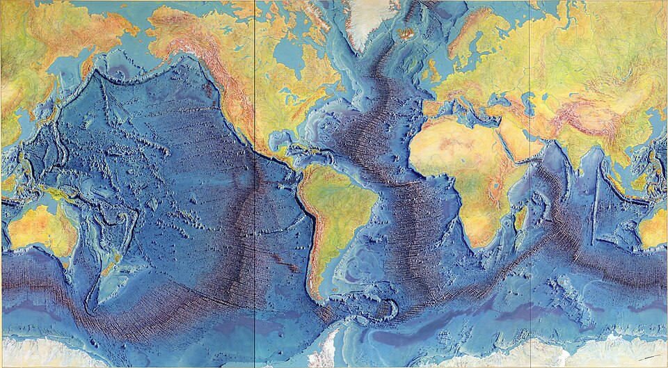
Of course I did. Wegener had proposed continental drift in 1912, and he was ridiculed for forty years for lack of a mechanism. Our 1957 map, and then The Floors of the Oceans two years later, finally gave something to see: a continuous mid-ocean ridge, a rift valley, a coherent system. When Harry Hess formulated seafloor spreading in 1960, he described in words what we were already showing with lines. I never claimed to have the theory — I provided the image without which no theory could stand. A map does not argue: it shows. And what ours showed was that the continents really were moving.
A map does not argue: it shows.
—You invented the way to draw these seafloors without any established convention. Where did you find your language?
In dry land, Bruce, where no one thought to look. There was no semiology for representing underwater relief — I had to invent one. So I turned to terrestrial topographic maps, the ones my father had taught me to love as a child, and I adapted their shading and profiling techniques to the abyss. The sediment cores and bottom photographs you brought back helped me verify my interpretations. Representing a world no eye has ever seen requires inventing the gaze before the drawing. I sought an image both accurate for the scientist and readable for the schoolchild — because a truth no one understands is useless.
Representing a world no eye has seen requires inventing the gaze before the drawing.
—We are finishing this great panoramic map with Berann. How do you feel knowing it will soon leave our walls?
Dizzy, I admit. For years, these seafloors existed only on my tracing paper, at this table. With Heinrich Berann, the painter, we are giving the data an almost living dimension — but I want you to know, Bruce: every relief he colors comes from our surveys, not his imagination. In my letter to the National Geographic Society, I insisted that it remain as rigorous as it is beautiful. I dream that it will hang in classrooms, that a child will look up and understand in a single glance that the Earth breathes beneath the oceans. If a map can teach millions of students what decades of debate could not prove, then all this time bent over my table will have been worth it.
Every relief he colors comes from our surveys, not his imagination.
—You always talk about schoolchildren before scientists. Why this obsession with the general public, Marie?
Because science that stays locked in journals dies, Bruce. I saw how many years it took for our colleagues to accept what our maps clearly showed. Adults have their certainties; children, on the other hand, look at a map without prejudice. If a student sees the mid-ocean ridge snaking sixty-five thousand kilometers around the globe, they understand plate tectonics better than many professors who scorned me. That's why I fight for accessible representation — a map you hang on the wall, not bury in a library. My father drew soil maps for farmers, ordinary people. I kept that idea: a map is meant to be read by everyone, or it serves no purpose.
Science that stays locked in journals dies.
—All these years, your name remained in the shadow of mine on our publications. How do you live with this silence around your work?
I won't lie to you, Bruce: some evenings it weighs heavily. My name often appears second, sometimes not at all, even though the tracings came from my hand. But I never worked for recognition — I worked so that truth would emerge from the data. You know me: I prefer a correctly traced rift valley to a thousand citations. The ocean floors do not lie, and someday someone will trace the story back to this table, to these sheets of tracing paper. I just have to do the work, again and again, until the truth appears. The rest — the honors, the medals — will come or not. The ocean, for its part, will keep the exact record of what I understood before others.
I prefer a correctly traced rift valley to a thousand citations.
—If, many years from now, people remember one thing about you, what would you want it to be?
Not a medal, Bruce, nor a title. I would want them to remember that a woman sitting at a table, denied ships and honors, could read the Earth better than those who traveled it. That the patience of a cartographer brought forth from the abyss the proof that continental drift was true. All I have are these ink-traced profiles, these overlays of tracing paper, these nights confronting my lines with your earthquakes. If a child, standing before our map, understands that the world moves beneath their feet, then I will not have lived in shadow — I will have illuminated the ocean floor. That is the only legacy that matters to me: one that is looked at, not recited.
A woman denied ships could read the Earth better than those who traveled it.


This imaginary interview was generated by artificial intelligence from sources documented in Marie Tharp's profile. It dramatises what the figure might have said based on what we know about them, but does not constitute attested historical testimony. For primary sources and factual documentation, refer to the full profile.