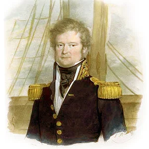

British geographer and geodesist, George Everest led the Great Trigonometrical Survey of India in the 19th century. He carried out the precise triangulation of the Indian subcontinent — a monumental undertaking that made it possible to accurately measure the Himalayan peaks. Mount Everest, the highest mountain in the world, was named in his honour in 1865.
George Everest(1790 — 1866)
George Everest
Royaume-Uni
8 min read
Frequently asked questions
Key Facts
- 1790: born at Gwernvale, Wales
- 1823: appointed Deputy Superintendent of the Great Trigonometrical Survey of India
- 1830–1843: leads the Great Trigonometrical Survey of India as Surveyor General of India
- 1841: completes the triangulation of the meridian arc across India from south to north (2,400 km)
- 1865: the highest peak in the world is officially named Mount Everest in his honour
Works & Achievements
Everest's masterwork: the precise geodetic measurement of the Indian meridional arc over 2,400 kilometres from Cape Comorin to the Himalayas. This titanic undertaking made it possible to produce an accurate map of the subcontinent and to calculate the heights of the Himalayan peaks.
A major two-volume scientific work in which Everest sets out the methodology and results of the measurement of the Indian meridional arc. Regarded as a founding reference in modern geodesy.
A public defence of Everest's geodetic methods in response to criticism from certain members of the Royal Society. The text bears witness to the lively scientific debates that surrounded the Great Survey.
Under Everest's direction, more than 100 permanent geodetic stations were established across India. This network formed the basis for all subsequent Indian cartography and enabled the first reliable measurements of the Himalayan peaks.
Everest was the first to systematise the use of Gauss's heliotrope under tropical conditions, thereby solving the problem of visibility between distant stations. This methodological innovation was adopted by other major colonial surveys.
Anecdotes
George Everest strongly objected to having the world's highest peak named after him. In 1865, when his successor Andrew Scott Waugh proposed naming 'Peak XV' in his honor, Everest argued that his name could not be transcribed into Hindi and was unpronounceable for local populations. His protest was ignored by the Royal Geographical Society.
Everest's fieldwork in India nearly cost him his life. In 1820, he contracted malaria and other tropical diseases so severe that he was forced to return to England for several years to recover. Despite fragile health and chronic pain, he returned to India in 1830 to complete his colossal undertaking.
The theodolites used by Everest in the Great Survey were enormous instruments weighing up to 500 kilograms. Transporting them through India's jungles, rivers, and mountains required teams of twelve to twenty men. Everest thus oversaw extraordinary convoys across near-impassable terrain.
Before Everest popularized the heliotrope — an adjustable mirror that reflected sunlight — trigonometric measurements over long distances were extremely difficult in India. Thanks to this instrument, his teams could signal to one another from hill to hill across dozens of kilometers, making unprecedented accuracy possible.
The Great Trigonometrical Survey of India, which Everest took charge of in 1823, mobilized thousands of Indian workers over several decades. This titanic scientific undertaking covered more than 2,400 kilometers from Cape Comorin at the southern tip of India to the foothills of the Himalayas, constituting the largest geodetic measurement operation ever carried out at the time.
Primary Sources
The operations described in these volumes embrace a period of twenty years, during which the survey was conducted under the most trying circumstances of climate, privation, and personal danger.
The object of the trigonometrical survey is to connect by a chain of triangles the astronomical and geographical observations made at the principal stations throughout the country.
The measurement of the arc of the meridian in India has been carried to a degree of precision hitherto unattained in any other country, by means of the improved instruments and methods employed.
I may add that Everest can be written in Hindi, but it is not easy of utterance by the natives of India.
Key Places
Birthplace of George Everest on 4 July 1790, in a rural area of Wales. He received the early upbringing of a young British gentleman there before joining the East India Company.
A city in northern India at the foot of the Himalayas where Everest established the permanent headquarters of the Great Trigonometrical Survey. The site was chosen for its strategic position between the Indian plains and the Himalayan peaks, and remains the seat of the Survey of India to this day.
The administrative capital of British India, where Everest reported to the East India Company and where the administrative and financial aspects of the Survey were handled. The nerve centre of British colonial power in Asia.
The British learned society founded in 1830, of which Everest was a distinguished member and where his geodetic work was presented and recognised. It was also in London that he spent his retirement and died on 1 December 1866.
The world's highest peak (8,849 m), named "Mount Everest" in 1865 in honour of George Everest by the Royal Geographical Society. Everest himself never saw this summit up close, but his geodetic work made it possible to identify it and calculate its altitude.
Liens externes & ressources
Références
Œuvres
Grande Trigonométrique Survey of India — Arc méridien de 2 400 km
1806–1843
An Account of the Measurement of Two Sections of the Meridional Arc of India
1830
A Series of Letters Addressed to His Royal Highness the Duke of Sussex
1839
Réseau de triangulation permanent de l'Inde
1823–1843
Introduction du héliotrope dans la géodésie tropicale
1832